CREATE
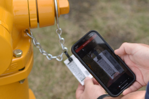
The American Cast Iron Pipe Company: American Flow Control (AFC) is a manufacturer of pipe, fire hydrants, and valves. AFC hired LandTech Consultants to develop a mobile application, American Mapper Pro, to assist utility owners and operators with collecting asset information and locations on their products. All AFC products are barcoded with data about the specific asset. AFC wanted this app to allow a user to scan a barcode to collect the asset’s location on a map, populate the asset information, and synchronize the data collected with the user‘s in-house GIS database.
INNOVATE
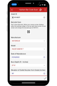
AFC wanted this application built for their water valve and fire hydrant products, as a first phase. LandTech built the app using the Esri Survey123 platform and source code, due to the tools available and the easy integration opportunity with a user’s existing geodatabase. Custom data collection forms were built to capture the asset’s location and allow users to scan a barcode and have attribute fields like make, model, and manufacture date, and other relevant information to be auto-populated. A map view was built into the application to give users easy access to their organization’s GIS maps. The final app design was based on AFC’s company branding style and protocol.
INTEGRATE
AFC was extremely impressed with the American Mapper Pro application developed. It provides an easy-to-use interface for users to efficiently collect location and attribute data on their valves and fire hydrants while syncing it back to their GIS database in real-time. It also gives AFC better tracking information on where their specific assets/products are used and helps easily identify them if needed. AFC is planning on expanding the app to incorporate their other products in the near future.
Learn more about the American Mapper Pro App.
This free app is now available through the Apple® App Store and on Google® Play. It’s configured to work with the ESRI ArcGIS platform by helping bridge the gap between construction, mapping, and asset management.


